
A satellite image of the airport in occupied Donetsk, where the Ukrainian Defense Forces hit a storage base for Shahed-type attack drones on the night of November 5-6, has been published online.
The image was published by the OSINT analyst Dnipro Osint ⟨Harbuz⟩.
The channel's author writes that as a result of the Ukrainian drone attack, one of the warehouses was completely destroyed. Another warehouse was damaged.
The satellite image shows two buildings. They are located in the southern part of the airport, near the parking lot. The image shows that virtually nothing remains of one of the buildings. The remains of walls are visible at the site of the second one.
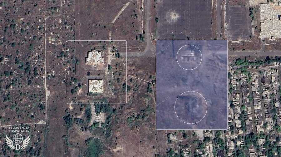 Satellite image of the destroyed Shaheds warehouse. Photo: t.me/DniproOfficial.
As the Ukrainian News agency earlier reported, on November 6, the commander of the Unmanned Systems Forces of the Armed Forces of Ukraine, Robert "Madyar" Brovdi, said that the Ukrainian Defense Forces hit the Shaheds launch site on the territory of the Donetsk airport.
The day before, on November 5, residents of occupied Donetsk reported a powerful explosion near the airport. After that, a fire broke out at the scene of the incident, and the sounds of secondary detonation were also heard.
In early August this year, it became known that the russians were turning the Donetsk airport into a launching site for Shaheds. On the territory of the airport warehouses for drones and combat units, as well as catapults for launching UAVs were found.
Who we are: About us, Contacts. How we write news and our principles: Editorial code. We did our best. If you found this valuable – please support us.
To request a correction, please send an email.